Preparing for the 2026 Super El Niño
By Mary Andersen
Residents of the Santa Cruz Mountains are no strangers to the power of nature, but the latest declarations from federal meteorologists suggest weather of historic proportions may be on the horizon. On August 13, 2026, the National Oceanic and Atmospheric Administration’s (NOAA) National Weather Service announced that, “El Niño is strengthening, with a greater than 90% chance of a very strong event during the Northern Hemisphere fall and winter 2026-27.” For mountain communities defined by steep terrain, winding roads, and a history of storm-induced landslides, the declaration is an early warning worth taking seriously starting now, not just as winter approaches.
A Muggier Mountain Summer
Before the rainy season has begun, San Lorenzo Valley residents may notice the air itself changing. Ocean waters off the California coast are already running well above normal, and climate scientist Daniel Swain of Weather West says that warmth will translate into a summer that simply feels different. Rather than spiking afternoon heat, Swain describes the effect as an “elevation of ‘baseline’ warmth” with nights running milder than usual, and afternoons in the redwoods turning increasingly muggy as the season wears on. He goes further, warning this could be a historically unprecedented stretch given how the current event is stacking on top of decades of background warming.
That extra moisture isn’t just uncomfortable, it can also fuel sudden storms. Elevated sea surface temperatures are expected to boost the North American monsoon, raising the odds of unusual shower and thunderstorm activity reaching beyond the mountains’ typical summer pattern. For the San Lorenzo Valley, that means a chance of dry lightning and flash flooding before the rainy season officially begins.
The Science Behind the Trend
El Niño is the warm phase of a recurring Pacific climate cycle, driven by heat and momentum moving from the tropical Pacific into the global atmosphere. The phenomenon is triggered when easterly trade winds weaken and warm western Pacific water surges eastward, suppressing the cool upwelling that normally occurs off South America.
NOAA declares an El Niño when sea-surface temperatures in the central equatorial Pacific remain at least above average for several overlapping three-month periods. This year’s event has already intensified well beyond that baseline. NOAA’s latest outlook assigns a greater than 90% chance that El Niño will become “very strong” during the Northern Hemisphere fall and winter — a category defined by temperature anomalies of at least For the October – December period, NOAA puts the probability of that threshold at 95%, and says there is a 69% chance the event will reach historic strength, surpassing every El Niño since 1950.
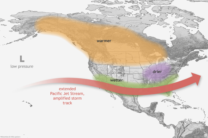
ABC7 meteorologist Drew Tuma explains the mechanics simply: “When we’re in El Nino conditions in the winter, the storm track typically favors Southern California, so much of California during these events tends to find wetter than average conditions.” That storm-track pattern can also bring rain to the Central Coast, Central Valley, Sierra Nevada, and at times the Bay Area and North Coast. But the farther north one goes, the less dependable the El Niño signal becomes.
Andrew Kruczkiewicz, a senior staff researcher at Columbia Climate School, cautions that “Every El Nino is different in terms of timing, magnitude, and geographic extent, and such differences lead to variability in the impacts on temperatures and rainfall.” That nuance matters for forecasting exactly how hard the Santa Cruz Mountains get hit, even as the broad odds tilt toward a wetter-than-normal winter.
What makes this event especially concerning is the backdrop it’s forming against. It’s not just El Niño. Swain’s point is that this year’s event is riding on top of a planet that’s already warmer than it used to be. And warmer air holds more water, which means storms have more fuel to work with when they finally break.
What It Means for Winter in the Mountains
NOAA’s outlook confirms that El Niño typically shifts the Pacific jet stream south, pulling the main winter storm track directly over California. Once that shift sets in, Weather West’s research suggests the danger compounds during strong El Niño years, significantly raising the odds of wet winters, extreme precipitation events, and flood risk across California and the Southwest. Storms during these winters also tend to arrive in clusters — so-called atmospheric river “families” — found in the research to be more than twice as likely during El Niño conditions. For canyon communities along the San Lorenzo River, that raises real concern about saturated hillsides, debris flows, and prolonged flooding rather than a single isolated storm.
Coastal neighborhoods, including Capitola and Santa Cruz, face a compounding risk. NOAA notes that high-tide flooding could become a higher risk on the West Coast as El Niño raises local sea levels through thermal expansion. KQED reported that Swain said the convergence of El Niño-driven sea-level rise, king tides, pressure changes, storm surge and back-to-back storms could produce as much as five to six feet of temporary inundation above historical high-tide levels in some places.
Lessons From the Past
National Weather Service Director Ken Graham cautions against assuming this winter will mirror any other: “Every El Nino is not the same; each one is unique with its own imprint on our weather.” The historic events of 1982-83 and 1997-98 brought devastating rainfall to California, while the 2015-16 “Godzilla” El Niño underdelivered in many areas — a reminder that strength alone doesn’t guarantee an outcome. Still, Swain argues the odds this year are meaningfully tilted: a very strong El Niño, he writes, may be “the single most important predictor of substantially increased odds of unusually wet conditions” and serves as an early-warning signal for large-scale flood risk.
Preparing Now
With months of advance notice, local officials are urging residents to act early:
- Register for alerts. Landlines are typically covered by reverse emergency systems, but cell phone owners must register their numbers with CruzAware — the county’s current alert and warning platform, to receive emergency notifications. CruzAware replaced CodeRED.
- Get a property assessment. Homeowners can schedule free, on-site erosion and drainage evaluations through the Resource Conservation District. rcdsantacruz.org
- Build an emergency kit. Prepare disaster supplies and a written Family Disaster Plan that accounts for pets and livestock.
- Check infrastructure now. Maintain private roads and clear gutters and drainage systems of debris before the rains arrive.
- Know your flood defenses. The county offers sandbag distribution sites.
“Even a strong El Niño doesn’t guarantee any particular outcome,” Swain cautions, but he believes the current forecast signal is strong enough that it’s worth discussing seriously now. For mountain residents, that conversation is best had while there’s still time to prepare for whatever the 2026-2027 rainy season brings.
Learn More
Weather West, California Weather and Climate Perspectives weatherwest.com
NOAA National Weather Service noaa.gov
Featured photo at top of page: This map shows the typical impacts of El Nino to the continental U.S. and Canada during Northern Hemisphere winter. (Image credit: NOAA)

Mary Andersen is a journalist, publisher, and editor of the San Lorenzo Valley Post, an independent publication dedicated to the people, politics, environment, and cultures of the Santa Cruz Mountains. mary@slvpost.com