Record-Breaking Warmth Is On the Way
Mid-March is going to feel a lot like July
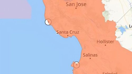
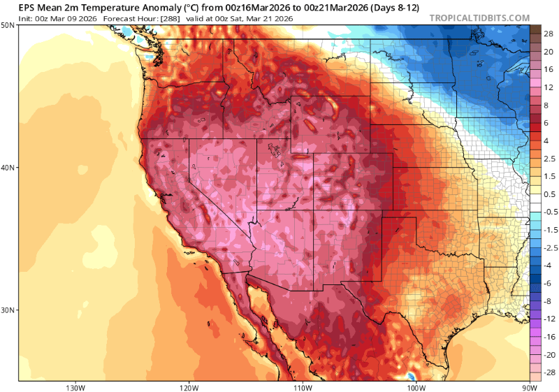
A sprawling heat event is taking shape across the American West. Forecasters are increasingly confident temperatures will shatter records during the week of March 16–21. And the Central Coast, from Santa Barbara County through the Salinas Valley and into Santa Cruz County, sits squarely in its path.
Daniel Swain, a climate scientist at UC Agriculture and Natural Resources and author of the Weather West blog, didn’t mince words. “It does indeed appear increasingly likely that an extremely anomalous and even record-breaking heatwave may envelop much of the SW about a week from now.”
That’s not routine language for early March.
Weather Mechanics
The culprit is a ridge of high pressure — a dome of sinking air that suppresses clouds and sea breezes, and bakes everything underneath it. The pattern belongs in late May or June, not the second week of March.
NOAA’s Weather Prediction Center confirmed on March 9 that record-breaking values are possible, especially Thursday and Friday of that second week. The Climate Prediction Center’s 6–10 day outlook flagged above-normal temperatures across the Southwest and California, with excessive heat risk extending into the following week.
Swain described what’s coming as “late spring or even mid-summer-like heat” that will “arrive and persist for a fairly extended duration.”
What the Central Coast Can Expect
The Central Coast has a natural defense during heat events: the marine layer. Cold water offshore keeps a lid on temperatures, pushing cool air inland through gaps in the coastal range. When a ridge this strong builds, that defense weakens. Offshore flow takes over, and the lid comes off.
NWS San Francisco Bay Area, which covers Monterey and San Luis Obispo counties, is forecasting temperatures 10 to 15 degrees above normal beginning as early as Wednesday March 11, with the heat intensifying through the end of the week. Their forecasters noted model output reaching into the 90s for San Jose and added, with some informality: “If you are a summer person, it’s coming for you.”
Santa Cruz and Monterey will get some protection from the marine layer in the mornings and evenings, keeping beach temperatures in the 70s and low 80s at peak. But afternoons, particularly with any offshore wind, are a different story.
Inland valleys will bear the brunt. Salinas sits behind the Santa Lucia Range, cut off from direct ocean exposure. Expect mid-to-upper 80s there, potentially touching 90°F. Hollister, Gilroy, and the Pajaro Valley face similar conditions: close enough to the coast to feel marine influence on a normal day, too far inland to count on it when offshore flow takes hold.
The Santa Cruz Mountains
The Santa Cruz Mountains are worth watching closely. Vegetation is currently green after a reasonably wet winter, which helps. But high heat, low humidity, and offshore winds pull moisture out of surface fuels faster than most people expect. Conditions can shift from benign to concerning in a matter of days.
No fire weather watches have been issued as of this writing. Residents in the San Lorenzo Valley and Scotts Valley should keep an eye on NWS alerts as the week of the 16th approaches. Offshore flow doesn’t have to be strong to be dangerous here. It just has to stick around.
The Marine Effect
The Pacific is unusually warm right now and that matters.
NOAA has confirmed a marine heatwave off the West Coast that’s been running since last summer, only the third time on record the ocean has stayed this warm this long into winter outside of an El Niño. Water temperatures are running 3 to 4 degrees Fahrenheit above normal.
That warmth undermines the coast’s natural air conditioning. The marine layer works by drawing cool air off cold water inland. When the ocean is warm, the temperature contrast shrinks, the layer weakens, and communities that would normally sit in a cool fog bubble — Monterey, Santa Cruz, Capitola — can find themselves in the 80s instead of the 60s.
What To Do
Treat next week like a summer heat event: hydrate, avoid midday exertion, check on neighbors who are elderly or without air conditioning. Watch NWS alerts for any fire weather watches in the Santa Cruz Mountains.
Sources: Daniel Swain / Weather West; NOAA Weather Prediction Center; NOAA Climate Prediction Center; NWS San Francisco Bay Area.
The San Lorenzo Valley Post is your essential guide to life in the Santa Cruz Mountains. We're dedicated to delivering the latest news, events, and stories that matter to our community. From local government to schools, from environmental issues to the arts, we're committed to providing comprehensive and unbiased coverage. We believe in the power of community journalism and strive to be a platform for diverse voices.